First Recorded Dataset#
This page records a dataset of 20 s with the camera and the LiDAR of the Maxxum. A drive script drives the vehicle, thus the session runs unattended.
Before You Start#
- Build the packaged game. Refer to Build the Game.
- Use a Python environment with
numpyandmatplotlib, for example the conda environmenttorchenv. - Keep 300 MB of the disk free. The dataset of this page uses 210 MB.
Record the Dataset#
-
Go to the repository root.
-
Write the drive script into the file
drive.json.{ "path": [[0, 0], [200, 0]], "keys": [ {"t": 0, "gear": 8, "speed_kmh": 0}, {"t": 2, "speed_kmh": 10}, {"t": 20, "exit": true} ] }The script follows a straight path of 200 m in front of the spawn pose. At 2 s it sets a speed of 10 km/h in gear 8. At 20 s it ends the session.
-
Start the session. Give absolute paths.
Packaged/Linux/Acres.sh -VehicleDemo -RenderOffscreen -SensorRecord -SessionLog \
  -VehicleSpawnU=625 -VehicleSpawnV=477 -VehicleSpawnYaw=180 \
  -DriveScript="$PWD/drive.json" -VehicleOutput="$PWD/out/first-dataset"
Expected Result
The game stops after approximately 30 s. The log on the terminal contains these lines.
ACRES_DRIVE_SCRIPT keys=3 path_points=2 file=/home/user/ACRES/drive.json
ACRES_SENSOR_START episode=/home/user/ACRES/out/first-dataset/sensors/episode-001 camera=1 lidar=8x180 gpu_lidar=1 proxies=16582 classified_components=8379
ACRES_DRIVE_SCRIPT_DONE t=20.00
ACRES_SENSOR_STOP episode=/home/user/ACRES/out/first-dataset/sensors/episode-001 truth=2402 imu=2400 gnss=201 lidar=201 camera=199 can=802 ins=0 lidar_points=230774 dropped_rows=0 camera_missed=1 camera_busy=0 lidar_busy=0 errors=0
The options have these functions.
| Option | Function |
|---|---|
-VehicleDemo |
Starts a session directly, without the menu. |
-RenderOffscreen |
Renders without a window. Remove it to see the session. |
-SensorRecord |
Records the sensors from the start of the session. |
-SessionLog |
Writes the session log of the vehicle. |
-VehicleSpawnU=, -VehicleSpawnV=, -VehicleSpawnYaw= |
Set the start pose on the survey grid. Cell (625, 477) is on the central farm road. A yaw of 180 degrees points to the west. |
-DriveScript= |
Gives the drive script. |
-VehicleOutput= |
Sets the session folder. The sensor episodes go into its folder sensors. |
Find the Files#
-
List the session folder.
Expected Result
out/first-dataset:
farm-config.json  farm-fields.csv    farm-water.bin    sensors               tractor.csv
farm-events.csv   farm-state.json    farm-water.json   session-summary.json  water-depth.f32
farm-field.bin    farm-visuals.json  farm-weather.csv  theta.f32

out/first-dataset/sensors/episode-001:
actions.jsonl  camera.jsonl  episode.json  imu.jsonl  lidar.jsonl          truth.jsonl
camera         can.jsonl     gnss.jsonl    lidar      sensors-config.json
The episode folder has these contents after the run of this page.
| Path | Content | Count | Size |
|---|---|---|---|
camera/front_<microseconds>.png |
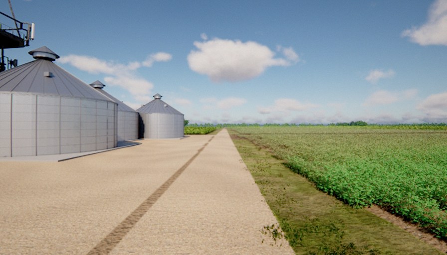
Camera images, 896 x 512 pixels, 10 Hz | 199 | 169 MB |
lidar/scan_<microseconds>.ply |
LiDAR point clouds, 8 rings x 180 columns, 10 Hz | 201 | 7.0 MB |
lidar/scan_<microseconds>.png |
A small top view of each scan | 201 | 2.0 MB |
camera.jsonl, lidar.jsonl |
One row for each image and each scan: time, physics step, poses, file | 199, 201 | 0.5 MB |
gnss.jsonl |
GNSS epochs, 10 Hz | 201 | 0.3 MB |
imu.jsonl |
IMU samples, 120 Hz | 2400 | 0.6 MB |
can.jsonl |
CAN frames | 802 | 0.2 MB |
truth.jsonl, actions.jsonl |
The true vehicle state and the controls at each physics step | 2402 | 2.4 MB |
episode.json |
The manifest: calibration, sensor parameters, counts and drop counters | 1 | 47 KB |
sensors-config.json |
The sensor configuration of the episode | 1 | 7 KB |
The file name of an image or a scan gives the episode time in microseconds. Session Log gives the format of each file.
Read the Dataset with Python#
-
Write this program into the file
read_episode.py.import json from pathlib import Path import matplotlib.image as mpimg import numpy as np episode = Path("out/first-dataset/sensors/episode-001") # The manifest: counts and drop counters. info = json.loads((episode / "episode.json").read_text()) print(info["schema"], info["state"], info["sensor_profile"]) print("counts ", info["counts"]) print("dropped", info["dropped"]) # One camera row and its image. row = json.loads((episode / "camera.jsonl").read_text().splitlines()[100]) image = mpimg.imread(episode / row["file"]) print(row["file"], image.shape, image.dtype, "t =", row["sample_time_s"], "s") # One LiDAR row and its point cloud (binary PLY: the header gives the fields). row = json.loads((episode / "lidar.jsonl").read_text().splitlines()[100]) data = (episode / row["file"]).read_bytes() header, body = data.split(b"end_header\n", 1) types = {"float": "<f4", "ushort": "<u2", "uchar": "u1"} lines = (line.split() for line in header.decode().splitlines()) fields = [(p[2], types[p[1]]) for p in lines if p[0] == "property"] points = np.frombuffer(body, dtype=np.dtype(fields)) ranges = np.sqrt(points["x"] ** 2 + points["y"] ** 2 + points["z"] ** 2) print(row["file"], len(points), "points, range", round(float(ranges.min()), 2), "to", round(float(ranges.max()), 2), "m") -
Run the program.
Expected Result
acres-episode-2-unreal complete tractor-default
counts  {'truth': 2402, 'actions': 2402, 'gnss': 201, 'imu': 2400, 'lidar': 201, 'camera': 199, 'can': 802, 'ins': 0, 'lidar_points': 230774}
dropped {'rows_queue_overflow': 0, 'lidar_busy': 0, 'camera_missed': 1, 'camera_busy': 0, 'camera_encode_backlog': 0}
camera/front_010108334.png (512, 896, 4) float32 t = 10.108333861 s
lidar/scan_010000001.ply 1149 points, range 6.7 to 59.63 m
The image array has four channels: red, green, blue and alpha.
The points are in the sensor frame: x forward, y left, z up, in metres.
The PLY header gives the names of all point fields, for example intensity, ring, class and return_index.
Read One Row#
Each line of a .jsonl file is one JSON object. This is the first row of camera.jsonl, with some keys removed.
{
  "physics_step": 13,
  "simulation_time_s": 0.108333339,
  "file": "camera/front_000100000.png",
  "width": 896,
  "height": 512,
  "pose": {
    "position_enu_m": [189.900381, 35.052070, 3.265629],
    "quaternion_flu_to_enu_xyzw": [0.0, 0.0, 1.0, -0.0]
  },
  "frame_index": 0,
  "sample_time_s": 0.100000005,
  "available_time_s": 0.150000005,
  "delivery_time_s": 0.325000017
}
| Key | Unit | Meaning |
|---|---|---|
physics_step |
The number of the physics step of the sample. One step is 1/120 s. | |
simulation_time_s |
s | The time of that physics step. |
file |
The image file, relative to the episode folder. | |
pose.position_enu_m |
m | The camera position: east, north and up from the origin of the tile. |
pose.quaternion_flu_to_enu_xyzw |
The rotation from the camera body frame (forward, left, up) to the world frame. | |
sample_time_s |
s | The time at which the sensor took the sample. |
available_time_s |
s | The sample time plus the delivery delay of the sensor configuration. |
delivery_time_s |
s | The physics time at which the recorder released the row. |
Examine the Dataset#
The key dropped of episode.json counts the samples that the recorder did not write.
In this run the recorder missed one camera image: camera_missed is 1.
Collect Data gives the meaning of each drop counter.
Next Steps#
- Collect Data: all kinds of recording, for the two vehicles and the implements.
- Sensors and Rigs: change the sensors and their rates.
- Session Log: the format of each file.